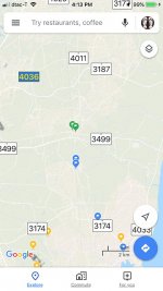
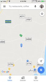
I'm not sure when this started, but when I was out for a long bike ride in unknown (to me) territory, I found I had a horrible time reading Google Maps. Somehow the contrast is so poor that it's almost impossible to see roads. Fiddling around with White Point and Contrast doesn't seem to help. Turning the screen brightness way up helps a bit, but also drains the battery mighty fast.
For reasons I don't understand, the Terrain map is easier to read than the Default map. I finally ended up adding the blue "Labels" (waypoints) so that I knew where to turn.
 .
.

Terrain on the left. Default (street map) on the right. You can see that there are many more roads visible on the Terrain map, but, for me, they are still hard to see when outside on a sunny day.

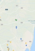
The terrain map in Chrome on an iMac isn't much better. Only major roads shown.
Unfortunately, the other iOS maps I've tried just don't have the road coverage offered by Google. Apple Maps is hopeless. HERE WeGo is pretty good if you zoom way in, but zoomed out the roads just kind of blend in with the background.
Any suggestions?
For reasons I don't understand, the Terrain map is easier to read than the Default map. I finally ended up adding the blue "Labels" (waypoints) so that I knew where to turn.
 .
.

Terrain on the left. Default (street map) on the right. You can see that there are many more roads visible on the Terrain map, but, for me, they are still hard to see when outside on a sunny day.

The terrain map in Chrome on an iMac isn't much better. Only major roads shown.
Unfortunately, the other iOS maps I've tried just don't have the road coverage offered by Google. Apple Maps is hopeless. HERE WeGo is pretty good if you zoom way in, but zoomed out the roads just kind of blend in with the background.
Any suggestions?


